Sir William Dixson was born in 1870. He began collecting books and manuscripts in the 1890s and focussed on Australiana, although his collection also includes many rare and valuable European works. Dixson’s collecting soon widened to include many formats - not only books and manuscripts but pictures, coins, medals, curios, relics, postage stamps, bookplates and maps.
In 1919 Dixson offered a collection of pictures to the Library on the condition that a suitable gallery was built to accommodate them. The Dixson Wing of the Library building was opened in 1929. Following his death in 1952, his entire collection including books, maps, coins and stamps, was transferred to form the Dixson Library. The Library's magnificent Chaucer windows, bronze entrance doors and Shakespeare Library chandelier were also donated by Dixson.
Southern lands revealed
Within Dixson's extensive map collection are dozens of fine hand coloured Dutch maps from the sixteenth and seventeenth centuries, including examples by Blaeu, Visscher, Hondius, de Wit, and Goos.
In the early 17th century the extensive trade networks of the Dutch East India Company established the Netherlands as the most powerful trading nation in Europe. The knowledge and skills of the Company's captains and navigators was supremely important, and demand for accurate and detailed charts and maps led to the rise of significant cartographers and map printing houses in Amsterdam. These maps were often the first visual representations of the latest discoveries of land and continents beyond the known European world. Over the century maps became not just navigational aids, but symbols of power and privilege with an increasing demand and supply for elaborately hand coloured charts and sumptuous atlases.
The fortunes of the Dutch trading company declined in the early eighteenth century with increased competition from France and England. The highly ornate decorations, the historiated cartouches, the allegorical depiction of the seasons and the elements were replaced with a more refined and classical decoration and map production showed a greater concentration on the accuracy and currency of the cartographic information.
About this item:
From the atlas, Theatrum orbis terrarum[The Theatre of the Whole World], this map depicts New Guinea as a large land mass shown at the bottom right corner. In 1584 it was not known whether it was an island or part of a larger continent. Below Java is a mysterious reference; Beach, pars continentis Australis. Marco Polo had named a southern land mass beachsuggesting a possible southern continent.
This fascinating and beautiful map combines the factual with the fantastic. A growing interest by the Dutch in the East Indies’ trading potential is reflected in the detail of the islands of Java, Sumatra, and the Moluccas or Spice Islands. While in the Pacific Ocean (called Orientalis), mermaids attend to their hair and sea monsters cause havoc off the coast of America.
About this item:
A beautiful hand-coloured engraved chart which depicts New Guinea and the west coast of Cape York, believed by the Dutch to be one land. This is one of the first printed maps to depict the Australian coastline. Drooge bocht (dry bight) at the centre is Torres Strait. The west coast of Cape York had been discovered and charted by Willem Jansz in the Duyfken in 1606, the earliest definite sighting of the Australian coastline.
Transcript:
This impressive 1652 map was possibly engraved by Pieter Goos. Claes Janszoon Visscher was the Dutch founder of a family of map-makers, engravers and publishers. The ornate border panels include engraved figures of Roman emperors, views of Rome, Amsterdam, Jerusalem, Tunis, Mexico, Havana, Pernambuco in Brazil, and San Salvador. Included are the allegorical figures of the four continents, and north and south polar views.
In the decorative cartouche there is a description of discovery of the Americas in 1499 by Christopher Columbus and America is depicted by an Indigenous American astride an armadillo with gold leaf detail on his weapons and clothing. In the background graze buffalo.
Enticed by the lucrative spice trade Marco Polo's 'Beach' is still shown as part of Magallanica sive Terra Australis Incognita.
This beautiful map exemplifies the Dutch engraving and decorative skills which flourished during the 17th century. The engraving process was a lengthy and detailed process which required the etching of the entire work onto a plate as a mirror image of the map whcih was then printed onto paper.
About this item:
In 1637, Hendrik Hondius published the first version of this map. It was regularly revised and reissued. This version is from Jansson’s Grooten Atlas and is one of the earliest printed maps to show Abel Tasman’s discoveries on the western coastline of New Holland, ‘Nova Hollandia detect Anno 1644’, the southern tip of Van Diemen’s Land and an edge of New Zealand. The large vignettes surrounding the hemispherical map depict scenes from South America and the Pacific region.
Transcript:
First included in Jansson's Novus Atlas 1657-58, this map shows the East Indies, the north coast of Australia, Carpentaria, and New Guinea. Tasman's second voyage of discovery in 1644 is indicated. A lavish cartouche depicts the exotic riches the Dutch found in the East Indies.
About this item:
From Goos' De Zee-Atlas ofte Water-Weereld, 1666, this world map shows all the discoveries of Tasman's voyages. This map remained unchanged for 10 years and through twenty editions until Goos' death in 1675.
About this item:
A map of the North Pole with corner details showing scenes of whaling. Frederick de Wit was the founder of the Dutch publishing family which produced lavish maps and atlases, based in Amsterdam.
About this item:
The Dutch firm of Van Keulen was founded by Johannes Van Keulen in 1680 and continued through until 1885. The strength of the company was in the production of marine charts. This plate was probably from theirGroote nieuwe vermeerderde zee-atlas ofte water-werelt and it depicts the Indian Ocean and coasts of eastern Africa, India, East Indies, and Australia, along with an elaborate cartouche of scenes from the exotic east.
About this item:
This is Carel Allard's second world map, published in his Atlas Minor of 1696 and hisAtlas Major of c.1705. Allard has depicted twin central hemispheres which are surrounded by eight smaller projections which illustrate the world from various perspectives. The Australian mainland is named Hollandia Nova with a partial coastline shown in both hemispheres from Great Australian Bight to Carpentaria.(Cape York Peninsula), with an additional portion of coastline named "Quri Regio". Tasmania is named Antoni van Diemens Land showing part of its southern coastline. New Zealand is named Zelandia Nova and only a partial portion of coastline is depicted.
About this item:
Designed for the French market, this map depicts the Australian east coast, detailing Captain James Cook's 1770 discoveries, along with the route of Abel Tasman in 1642. The directions of regular and variable trade winds are also illustrated.
About this item:
Captain Samuel Wallis in command of theDolphin, along with the Swallowcommanded by Philip Carteret were given the objective of sailing around Cape Horn and through the Strait of Magellan: the most southern points of South America. They were then to travel westward in search of land that was thought to lie between Cape Horn and New Zealand. The journey through the Straits was undertaken under very trying conditions. The strong westerly winds and stormy waters resulted in the two ships becoming separated. The Dolphin took a northerly route across the Pacific through the Society Islands, Wallis Island then north to the Gilbert and Marshall Islands whereas the Swallow travelled south of Easter Island to Pitcairn then north of the Fijian Islands and New Caledonia through to the Solomon Islands. The crews of both vessels ended their travels at Batavia.
About this item:
Prior to his explorations in the Pacific, James Cook served in the Royal Navy in North America during the Anglo-French Seven Years’ War and saw his first campaigning off Louisbourg, Île Royale (Cape Breton Island). Cook surveyed the St Lawrence gulf and river in Quebec and charted the river in detail to enable a large armada of ships to enter. This chart of the St. Lawrence River shows settlements, ship channels, and anchorages. The soundings shown in fathoms. The original version of this map by James Cook was published in 1760.
T.L. Mitchell's peninsular war
Prior to his posting to New South Wales as Surveyor-General, Thomas Mitchell fought in the Peninsula War. He was second lieutenant in the 95th Regiment at the battles of Ciudad Rodrigo, Badajoz and Salamanca. Utilising his skills as a surveyor, he was tasked with providing topographical intelligence. After the War, he was selected by Sir George Murray, the quartermaster-general, to provide a cartographical record of the battles based on the many army surveys done during the conflict. The collection held by the State Library appears to be Mitchell’s own personal collection of maps. It does not include any final states, but consists of trial proofs of lithographs and engravings of most of the maps in various degrees of completeness, together with a number of manuscript maps. In July 1838, Mitchell obtained a further twelve months leave from his work in New South Wales as he was still working on the plans of the Peninsular battles. These were finished at the end of 1840 and, as published by James Wyld, are beautiful examples of Mitchell's skill as a draftsman.
About this item:
Keen to lessen British power in Europe and to prevent British trade with European ports, Napoleon's strategy was to invade Portugal, the only remaining European port still open to British imports. The invasion of Spain and Portugal resulted in the Spanish and Portuguese royal families being deposed and battles broke out along the Iberian Peninsula between the French and the local militas. The British landed an expeditionary force under the command of Sir Arthur Wellesley (later to become the Duke of Wellington), on 1st August 1808. The British were victorious at their first two battles against the French at Rolica on 17 August 1808 and then at Vimiero on 21st August 1808.
Prior to his posting in New South Wales as Surveyor-General, Thomas Mitchell served as second lieutenant in the 95th Regiment in the Peninsula War at the battles of Ciudad Rodrigo, Badajoz and Salamanca. He was tasked with providing topographical intelligence and after the War, was selected by Sir George Murray, the quartermaster-general, to provide a cartographical record of the battles based on the many army surveys done during the conflict. The collection held by the State Library appears to be Mitchell’s own personal collection of maps. It does not include any final states, but consists of trial proofs of lithographs and engravings of most of the maps in various degrees of completeness, together with a number of manuscript maps. In July 1838 Mitchell obtained a further twelve months leave from his work in New South Wales as he was still working on the plans of the Peninsular battles. These were finished at the end of 1840 and, as published by James Wyld, are beautiful examples of Mitchell's skill as a draftsman.
Early settlement and exploration
The collection contains a number of maps relating to the early settlement and exploration of Australia and New South Wales. Some examples include maps and drawings of Lord Howe Island and Port Stephens by surveyor Charles Grimes, and maps and sketches of the early settlements of NSW and crown land allotments by early colonial figures such as John Hunter. Maps from the second half of the 19th century show the planning and development of metropolitan Sydney, with Sands and Kenny maps of street layouts, names and landmarks, plans and options for the improvement of Circular Quay and health maps from 1900 detailing the planned resumption of land around the areas of the Rocks, Millers Point and Dawes Point.
About this item:
This is a manuscript map which details the profile of Lord Howe Island attributed to Henry Lidgbird Ball, the Surveyor and Commander of the Supply. There is an inset map at upper right which reads: A view of Balls Pyramid laying S.E. of Lord Howe Islands, 13 miles.
About this item:
Grimes was appointed in 1790 as Deputy-Surveyor of roads, employed on Norfolk Island. He stayed on the Island for 4 years and was appointed head constable. In April 1794 he was posted to the mainland to assist the Surveyor-General, Augustus Alt. He was first stationed at the Hawkesbury River and then at Toongabbie.
In February 1795 he visited Port Stephens and surveyed the area for Lieutenant-Governor Paterson. Grimes reports that the Harbour and Rivers above Direction Island (now called Boondabah or Middle Island) were traced by rowing from point to point and estimating the distance by the eye. 'Below Direction Island, by taking the bearings from the vessel, as she lay at anchor off Salamander Point the country to the South and West is a mangrove swamp, on the north side there are a few hills, but the ground is very bad and the timber, low. There are mangroves and oysters, as far up the Rivers as we went, tho' the water is perfectly fresh.'
Grimes has also included depth soundings, information regarding the bar across the entrance to the harbour and notes about locations of fresh water.
About this item:
Signed by John Hunter, who had become Governor in September 1795, this map depicts the boundaries of the settlements in the Sydney region. The note at the top of the map explains, 'the red lines shew the country which lately has been walked over ... The places which are coloured green are where our principal cultivation and farms are.'
About this item:
From 1791 to 1831, the governors of New South Wales issued free grants of land on behalf of the Crown to individuals to encourage the settlement of the colony. Evidence of ownership was provided by a document known as a Crown grant. This map shows grant lot numbers and acreages in 1814. Several place names included on the map have been replaced. At point H: ‘Bulanaming’ was used up until the 1820s for the area between Sydney and the Cooks River. In 1810 Governor Macquarie renamed the Green Hills region as Windsor although the former name appears on this map.
About this item:
John Septimus Roe was posted as a master's mate to the surveying service in New South Wales then under the command of Phillip Parker King. He arrived in the colony in September 1817 and conducted three hydrographic coastal surveys over the next three years, which included circumnavigating Australia. He was appointed Lieutenant in April 1822. On this nautical chart which encompasses Port Jackson from the Heads west to 'The Flats' (Homebush Bay), Roe has indicated the soundings or the depth of the harbour, recorded in fathoms. He has noted the tidal changes and the western and eastern channels near the entrance to the Heads.
About this item:
This map was produced around 1850 in Sydney by William Meadows Brownrigg, a surveyor and lithographic printer. It is noted at the bottom of the map that it was drawn on stone by William Henry Fernyhough who was a silhouette artist, lithographer and draughtsman.
By 1850, the Sydney settlement stretched across the Harbour to the north shore, identified as the town of St Leonards. Land ownership and settlement has moved northwards marked as the district of Willoughby. Owners such as Wolstonecraft [sic], Berry and Mossman [sic] have large pockets of land in this area. Across in the east, landowners names are a roll call of signficant characters of early Sydney: John Piper, Thomas Mitchell, William Wentworth, Alexander McLeay. Settlement runs along the length of the Parramatta road through districts such as Concord and Liberty Plains. The Windsor road, Pennant Hills road and Kissing Point road spread out from the Parramatta township. The Female Factory, the Female Orphan School and the gaol are indicated at Parramatta and the Marsden name continues to be associated with this area.
About this item:
Published by Sands and Kenny, the publishers of numerous post office directories, business direcories and street maps, this map was produced during a time of strong growth in the Australian colonies as immigrants from all over the world were arriving in port during the gold rush era. No longer a struggling settlement, this map depicts a growing city.
Roads, railways, public buildings and reserves are identified. On Macquarie street there is the Legislative Council Chamber, the hospital and Government Printing Office. The Australian Subscription Library is located at the corner of Macquarie and Bent streets. Numerous churches and banks are identified.
The wharves alongside Darling Harbour have the names of their company owners and at the southern end of town are the Benevolent Asylum, the Devonshire street burial grounds and breweries, such as the Albion and Kent breweries in Surrey Hills and Chippendale.
About this item:
The first Royal Tour of Australia was in 1867 - 68 with the official visit of Prince Alfred, the Duke of Edinburgh, the second son and fourth child of Queen Victoria and Prince Albert. He was created Duke of Edinburgh, Earl of Kent and Earl of Ulster on 24 May 1866 and in January 1867 left England on an extensive world tour as commander of the H.M.S. Galatea.
The Duke spent nearly 5 months in Australia including visits to Adelaide, Melbourne, Sydney, Brisbane and Tasmania. The H.M.S. Galatea arrived in Sydney on 21 January 1868. According to newspaper reports no less than 100,000 people welcomed the Duke with fervour. 'Flowered arches spanned the streets, flags fluttered from public buildings, and illuminations lit the scene by night'. A letter to the editor from the Sydney Morning Herald, 18 January, reported that Garden Island would be open to the public....in order to afford an opportunity for those desirous of seeing the arrival of H.R.H. the Duke of Edinburgh.' Unfortunately, on 12 March 1868, while attending a picnic at Contarf, the Duke was wounded in an assassination attempt by James O'Farrell, a Fenian sympathizer. The Library holds an eyewitness account written by Emily Thorne of the attempted assassination. Curiously, an article in theSydney Morning Herald in 1932 claims that on board the Galatea was the Duke's mascot, an elephant, presented to the Duke by an Indian 'of some consequence'. The elephant was allowed to roam around Cockatoo Island while the Galatea was docked and given an overhaul.
About this item:
British Naval officer, John Thomas Ewing Gowlland was appointed to the Australian survey as chief assistant in 1865. He later took command of the survey of the New South Wales coast and compiled Admiralty charts of the coast and the tidal waters of the Richmond, Clarence, Hunter and Hawkesbury Rivers. Gowlland also surveyed Port Jackson and made the first plans of Garden Island. This large chart, measuring 230 cm in length is a fine example of Gowlland's skills in hydrography and maritime charting.
About this item:
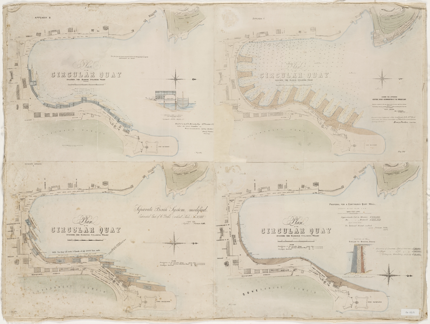
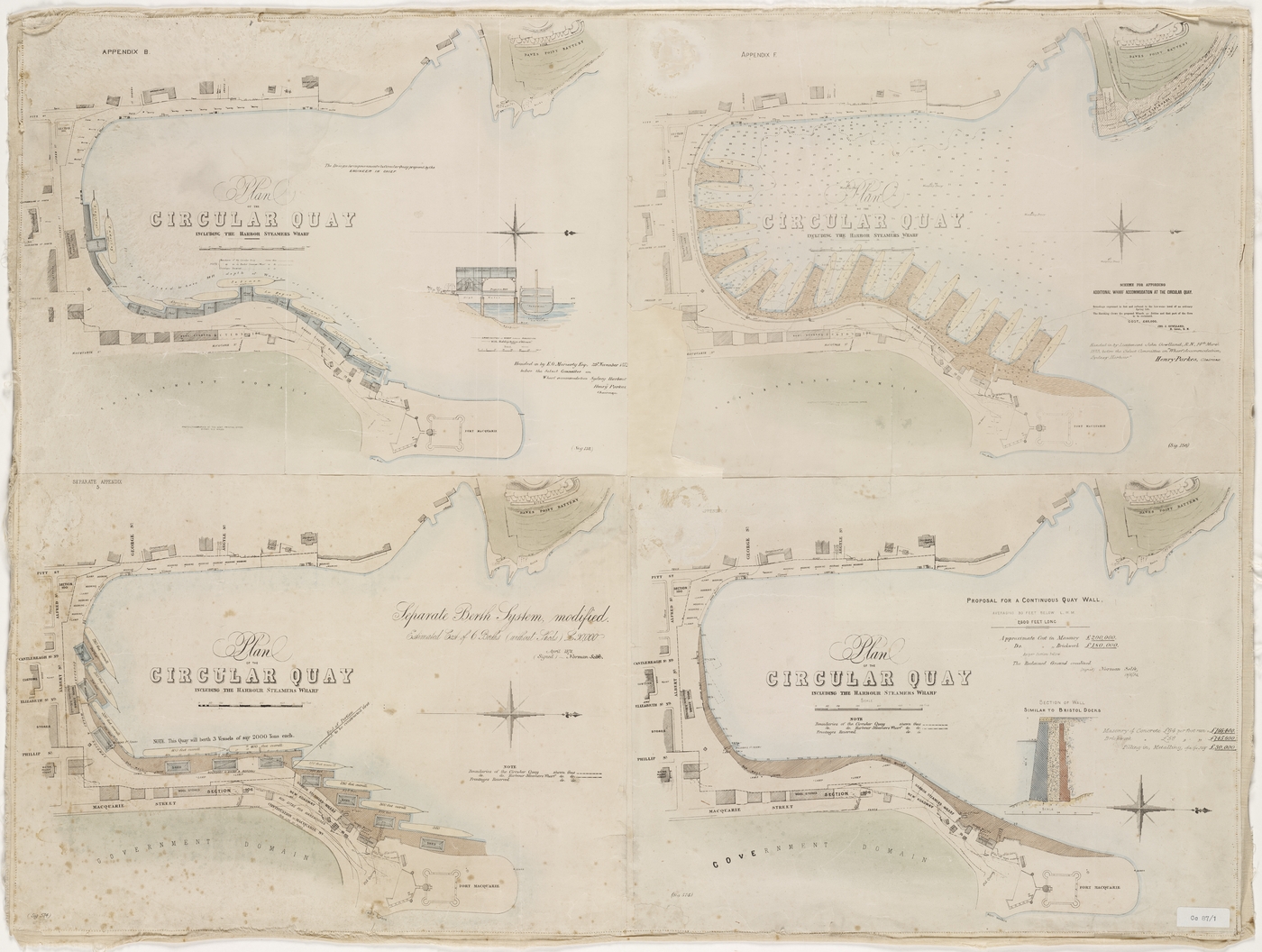
In 1872 a Select Committee was set up 'to consider and report upon the best means of improving the Wharf Accommodation of Sydney Harbour, and providing greater facilities for the loading and unloading of Vessels.' According to the Chairman of the committee, Henry Parkes, 'the Circular Quay in its present state, looking to the commercial importance of the port, is a disgrace to the country.'
This map shows a selection of 4 plans submitted to the Committee. The plan considered the most advantageous by the Committee was the one submitted by Lieutenant John Gowlland, seen here as Appendix F (top right). According to Gowlland, his plan 'gives the greatest amount of wharf accommodation in a limited space; that it is much easier to get vessels into and out from their berths, and that it is the least expensive.' According to Gowlland it would cost approximately 60,000 pounds.
An additional feature of the Gowlland plan was the extension of George Street down to Dawes point where a safe area would be created for loading and unloading public passengers taking pleasure trips around the harbour, separate from the congestion of the main port. This set of plans was prepared by Norman Selfe, the well known draftsman and engineer, who later designed a cantilever harbour bridge from Dawes Point to McMahon's Point.
About this item:
As part of the response to the bubonic plague outbreak in 1900, the New South Wales government enacted the Darling Harbour Wharves Resumption Act 1900 (Act No.10, 1900) which enabled resumption of land from Circular Quay to Darling Harbour. Approximately 900 houses were bought as well as the surrounding wharves, bond stores, factories, workshops, offices and pubs. According to the act, the area was'resumed for the purpose of carrying out a system of public wharves and approaches thereto at Darling Harbour, and the waters at Port Jackson adjacent thereto..'
An article in the 12 May edition of the Town and Country Journal, revealed that it cost the Government £2,000,000 to carry out these resumptions. The resumptions encompassed the western side of Sussex street, along Kent street, down the hill and around Miller's Point until Dawes Point.
About this item:
Like an early map overlay, this 1900 map depicts two maps of Sydney Cove superimposed over each other. The red lines indicate the original coastlines depicted in James Meehan's 1807 map and the dark lines indicate the street blocks existing in 1807 with a 1900 map indicating streets, buildings and wharves.
Beyond borders
A number of maps in the collection detail exploration and charting of lands beyond Sydney – including the Hunter River and the Newcastle region, the ‘interior’ of NSW showing discoveries beyond the Blue Mountains, the Great Western Road to Bathurst, Van Dieman’s Land (Tasmania), and Brisbane and Moreton Bay (Queensland). Several maps detail the ‘North Australian Expedition’, Augustus Charles Gregory’s grand expedition of 11,000km by sea and land commencing in Moreton Bay and travelling overland to the Victoria River (north-west Northern Territory) with the intention of discovering an inland sea.
About this item:
This 1819 manuscript map traces the Hunter River from Newcastle. It has been annotated in pencil, noting where there is good soil, fine grassland or swampy ground.
Governor Macquarie had journeyed to Newcastle in July of 1818 and explored the Hunter region, naming several landmarks. Macquarie notes in his journal, 'This is a very beautiful and Picturesque River, and has sufficient depth of Water in it as far as I have gone up it for a Vessel of 50 Tons Burthen, and the Land on its Banks being excellent, it is in every respect fit for establishing Settlements on.'
Three insets showing local buildings, one being Christ Church, Newcastle, an untitled building and one map entitled 'Entrance to Port Jackson, 1819'.
About this item:
In 1797 Lieutenant John Shortland explored the Newcastle region, north of Sydney, while searching for escaped convicts. He described the Hunter as ‘ a very fine river ’. However, for many years the harbour was considered difficult with a number of navigational hazards created by shallow sandbanks and the treacherous nature of the channel between Nobbys Head and the mainland. In the early years of settlement attempts were made to create a breakwater across this channel. It wasn’t until the 1830s that serious plans were made to create a permanent barrier. In 1849 the Colonial Engineer, George Barney, prepared a report on the Harbour. This Rough sketch of Newcastle Harbour shewing the Breakwater was prepared to accompany the report. This is a unique manuscript sketch of Newcastle harbour from the collection.
About this item:
This is a hand coloured plan showing the sands between the beach and harbour in Newcastle in 1850. In 1852 Captain John Bull was appointed as Superintendent of Works at Newcastle Breakwater. Bull supervised the building of the breakwater using stone excavated from Nobbys Head using convict labour. The height of Nobbys Head was reduced from 62 metres to 27.5 metres by the excavation work.
About this item:
Dedicated to 'the Right Honourable the Earl Bathurst, K.G. one of His Majesty's principal Secretaries of State', this John Oxley map illustrates the early discoveries made into the interior of New South Wales. It was published in London by the well-known map publisher, Aaron Arrowsmith. This map encompasses the area from Moreton Bay to Port Phillip, and illustrates the exploring routes of William Howe, Meehan, Evans, Cunningham and Oxley between 1817-1823. These men were explorer-surveyors who travelled into the inland of New South Wales and mapped the western river systems. Oxley's map is remarkably detailed, providing lengthy descriptions on the land, the topography and the extent of water available, in some cases, the barren lack of water and the poor quality of soil.
About this item:
Dedicated to Captain Phillip Parker King R.N, this map of eastern New South Wales shows the nine counties, with notes and descriptions. Included are eleven views of 'Sidney' [sic] and the coast which were ascribed on the previous 1825 edition to J.W. Lewin. Cross's map was included in James Atkinson's Account of the state of agriculture & grazing in New South Wales, published in London in 1826. Intended to encourage British immigration by highlighting the beauty of New South Wales and the opportunities open to settlers, this publication focused on'observations of the soil and general appearance of the country, and some of its most useful natural productions with an account of the various methods of clearing and improving lands, breeding and grazing live stock, erecting buildings, the system of employing convict and the expense of labour generally and the mode for applying for grants of land, for those who are about the emigrate to that Country'.
About this item:
Diamond Swamp Creek in the County of Roxburgh is a northern tributary of the Fish River, flowing south through good agricultural land which had been taken up by a number of landholders such as Lawson and Mitchell in the early 19th century. The original land grants were located on the right bank of the Macquarie River in 1818, according to Governor Macquarie's plan for the settlement.
In 1825, Lord Bathurst had issued instructions regarding land policy that the colony was to be divided into counties, hundreds and parishes. Consequently the Bathurst district was divided into townships with blocks on which the scale of land grants to free settlers was determined. As part of this policy, new land boundaries were created. The counties of Bathurst and Roxburgh were created and the dividing line between these two was the Macquarie River. Part of the town of Bathurst lay on the right side of the river was named Kelso and was subsumed into the County of Roxburgh.
About this item:
Published by Aaron Arrowsmith in 1798, this map details a section of the south eastern coast of Tasmania from South West Cape to Maria's Island. It traces Captain John Hayes' expedition in 1794 in the two British ships, the Duke of Clarenceand of Duchess of Bengal. Intending to explore New Guinea, he was prevented by strong winds and decided to explore New Holland. Reaching Adventure Bay in April he left Van Diemen's Land on 9 June. During this time he discovered and named the Derwent River, Risdon Cove and Cornelian Basin. This map features Bruny Island, however Hayes gave it the name William Pitt's Isle. Unknown to Hayes, the French expedition of Admiral Bruni D'Entrecasteaux had been in the region exploring, charting and naming it only two months prior to Hayes.
About this item:
In 1824 the Van Diemen's Land Company was formed to develop a pastoral and agricultural settlement in north west Tasmania ( then known as Van Diemen's Land). The Company architect and surveyor, Henry Hellyer, arrived on 4 March 1826 in the Cape Packet with other officers of the Van Diemen's Land Company and the first settlement was established at Circular Head.
This ink and wash map, dated September 1828, documents the survey made by Hellyer on behalf of the Company. It includes the tracks of Hellyer and Joseph Fossey in 1827 to 1828 and shows the topography from Pipers to Duck Rivers and inland to Cradle Mountain. It describes the terrain and significant landforms including the peak they climbed on 14 February 1827, appropriately named St Valentine's Peak.
Although Hellyer's initial assessment of the land was positive the land around St Valentines Peak was sub-alpine, featuring long, wet and bitterly cold winters. The native snow grass lacked nutrition and in the first few winters over 5000 sheep died of cold and malnutrition. Henry Hellyer committed suicide in 1832.
'Where tinted yellow it indicates a Grassy Country consisting of Plains without Trees or Open Forest. The Red tint shews the Roads for Carts and cattle which the Company have made into the newly discovered Territory. The Green spots show The Company’s principal stock stations and Establishments at the present moment. The Blue Tint - Water and Lakes. The dotted Lines show the tracks of exploring Parties.' A note on the top left of the map, near the Duck River, states that'Mr Longmar surveyor unfortunately drowned in crossing Duck River, April 1827 on his return from the west coast'
About this item:
In 1824 William Hilton Hovell (1786-1875), and Hamilton Hume (1797-1873) set out from Hume's property near Gunning on an overland expedition to Westernport. On 16 December 1824 they sighted Corio Bay in Port Phillip, which they believed to be Westernport. Their journey opened the way for the settlement of Port Phillip.
No original map documenting the journey has survived. This manuscript map of the journey is believed to be a copy possibly sketched by Thomas Mitchell from a rough sketch provided by Hume to Mitchell following the completion of the journey. The arrows mark both the outward and return journeys. Sir William Dixson acquired the map through Thomas Mitchell's grandson. The Library holds additional information on the journey including Hovell's papers from 1811 - 1875.
About this item:
This is a cadastral map showing buildings, allotments, reserves and some physical features of the town of Brisbane. This map appears to be based on the manuscript map sent as an Enclosure to Governor Gipp's Despatch no. 100 of 1 July 1839.
About this item:
Augustus Charles Gregory was employed by the Surveyor-General, John Roe in Perth in 1841 and was promoted to Assistant Surveyor. Working outside of Perth, Gregory was employed in surveying areas marked out for roads and towns.
After several successful exploring expeditions north of Perth, Gregory was selected to lead a scientific expedition of the north of Australia consisting of eighteen men in 1855-56, financed by the British Government and sponsored by the Royal Geographic Society in London. One of the aims of this expedition was to discover the extent of natural resources in the north of the country.
Starting out at Moreton Bay, the expedition travelled over 11,000 km by sea and land, up the Victoria River from it’s mouth in the north-west of the Northern Territory, traced Sturt’s Creek for almost 500 km, hoping it would end in an inland sea; however it filtered out into desert. They then ventured east and explored the Elsey, Roper and Macarthur River systems, crossed and named the Leichhardt River and then travelled back to Brisbane via the Flinders Burdekin, Fitzroy and Burnett Rivers.
These maps show the topography along the route taken by North Australian Exploring Expedition, from Point Pearce, up the Victoria River and 300 miles along Sturt Creek, ending in the Sandy Desert.
The fantastic map collection which made up part of the 1952 bequest reflects Dixson’s interest in early navigation, geography and the European exploration and settlement of the Pacific, in particular Australia. The collection includes examples from the 16th through to the 20th century including hand coloured maps by Dutch mapmakers, Ortelius, Blaeu, de Wit, and Jansson. Many of the maps are rare manuscript copies by inland explorers including Sir Thomas Mitchell, Ludwig Leichhardt and Augustus Gregory.
With thanks to the collaborative support of our many generous benefactors, we have been able to scan over 1 000 rare and beautiful maps from the collection.
Photographic portraits of Sir William Dixson including views of family residences, ca. 1875-1935
{"type":null,"clickUrl":"https:\/\/prod.corp.slnsw.skpr.live\/collection-items\/photographic-portraits-sir-william-dixson-including-views-family-residences-ca-1875","thumbnail":"https:\/\/prod.corp.slnsw.skpr.live\/sites\/default\/files\/styles\/thumbnail\/https\/s3-ap-southeast-2.amazonaws.com\/prod--slnsw-corporate-site\/uploads\/2018-06\/collection-items\/5251\/a7159003h.jpg?itok=KS0F0h_1","thumbnailLarge":"https:\/\/prod.corp.slnsw.skpr.live\/sites\/default\/files\/styles\/large\/https\/s3-ap-southeast-2.amazonaws.com\/prod--slnsw-corporate-site\/uploads\/2018-06\/collection-items\/5251\/a7159003h.jpg?itok=htHtm4w1","mediaDerivativeUrls":{"thumbnail":"https:\/\/prod.corp.slnsw.skpr.live\/sites\/default\/files\/styles\/thumbnail\/https\/s3-ap-southeast-2.amazonaws.com\/prod--slnsw-corporate-site\/uploads\/2018-06\/collection-items\/5251\/a7159003h.jpg?itok=KS0F0h_1","large":"https:\/\/prod.corp.slnsw.skpr.live\/sites\/default\/files\/styles\/large\/https\/s3-ap-southeast-2.amazonaws.com\/prod--slnsw-corporate-site\/uploads\/2018-06\/collection-items\/5251\/a7159003h.jpg?itok=htHtm4w1","responsive__quarter_hd":"https:\/\/prod.corp.slnsw.skpr.live\/sites\/default\/files\/styles\/responsive__quarter_hd\/https\/s3-ap-southeast-2.amazonaws.com\/prod--slnsw-corporate-site\/uploads\/2018-06\/collection-items\/5251\/a7159003h.jpg?itok=WH2vEl6o","responsive__half_hd":"https:\/\/prod.corp.slnsw.skpr.live\/sites\/default\/files\/styles\/responsive__half_hd\/https\/s3-ap-southeast-2.amazonaws.com\/prod--slnsw-corporate-site\/uploads\/2018-06\/collection-items\/5251\/a7159003h.jpg?itok=N_OFLe-k","responsive__full_hd":"https:\/\/prod.corp.slnsw.skpr.live\/sites\/default\/files\/styles\/responsive__full_hd\/https\/s3-ap-southeast-2.amazonaws.com\/prod--slnsw-corporate-site\/uploads\/2018-06\/collection-items\/5251\/a7159003h.jpg?itok=Y5fLqVgz"},"mediaUrl":null,"mediaMime":null,"transcriptUrl":null,"width":653,"height":1050}
This story has been developed with the support of the State Library of NSW Foundation. We would like to acknowledge the generosity of various benefactors.