Why is Circular Quay there?
Student activities
Task no. 1
Acquiring and processing geographical information – Why is Circular Quay there?
Examine sources 10 to 19 and research further to investigate the reasons Circular Quay was constructed and its shape, use and features over time.
Record the uses and changes to Circular Quay since British Colonisation in the table found in the downloadable resource.
View of Sydney Cove / painted by Thomas Watling, 1794-1796?
{"type":"image","clickUrl":"https:\/\/prod.corp.slnsw.skpr.live\/collection-items\/view-sydney-cove-painted-thomas-watling","thumbnail":"https:\/\/prod.corp.slnsw.skpr.live\/sites\/default\/files\/styles\/thumbnail\/https\/s3-ap-southeast-2.amazonaws.com\/prod--slnsw-corporate-site\/uploads\/2018-06\/collection-items\/49891\/a928723r.jpg?itok=zxn1857e","thumbnailLarge":"https:\/\/prod.corp.slnsw.skpr.live\/sites\/default\/files\/styles\/large\/https\/s3-ap-southeast-2.amazonaws.com\/prod--slnsw-corporate-site\/uploads\/2018-06\/collection-items\/49891\/a928723r.jpg?itok=ja5tkuvv","mediaDerivativeUrls":{"thumbnail":"https:\/\/prod.corp.slnsw.skpr.live\/sites\/default\/files\/styles\/thumbnail\/https\/s3-ap-southeast-2.amazonaws.com\/prod--slnsw-corporate-site\/uploads\/2018-06\/collection-items\/49891\/a928723r.jpg?itok=zxn1857e","large":"https:\/\/prod.corp.slnsw.skpr.live\/sites\/default\/files\/styles\/large\/https\/s3-ap-southeast-2.amazonaws.com\/prod--slnsw-corporate-site\/uploads\/2018-06\/collection-items\/49891\/a928723r.jpg?itok=ja5tkuvv","responsive__quarter_hd":"https:\/\/prod.corp.slnsw.skpr.live\/sites\/default\/files\/styles\/responsive__quarter_hd\/https\/s3-ap-southeast-2.amazonaws.com\/prod--slnsw-corporate-site\/uploads\/2018-06\/collection-items\/49891\/a928723r.jpg?itok=vH4sjcCR","responsive__half_hd":"https:\/\/prod.corp.slnsw.skpr.live\/sites\/default\/files\/styles\/responsive__half_hd\/https\/s3-ap-southeast-2.amazonaws.com\/prod--slnsw-corporate-site\/uploads\/2018-06\/collection-items\/49891\/a928723r.jpg?itok=fFZ9UwOe","responsive__full_hd":"https:\/\/prod.corp.slnsw.skpr.live\/sites\/default\/files\/styles\/responsive__full_hd\/https\/s3-ap-southeast-2.amazonaws.com\/prod--slnsw-corporate-site\/uploads\/2018-06\/collection-items\/49891\/a928723r.jpg?itok=yTIjyuhc"},"mediaUrl":"https:\/\/digital.sl.nsw.gov.au\/delivery\/DeliveryManagerServlet?dps_pid=FL3190258&dps_func=stream","mediaMime":"image\/jpeg","transcriptUrl":null,"width":800,"height":545}
View collection item detail8OZkB2xgBwWa4
Sydney Cove, Port Jackson , ca 1802
{"type":"image","clickUrl":"https:\/\/prod.corp.slnsw.skpr.live\/collection-items\/sydney-cove-port-jackson","thumbnail":"https:\/\/prod.corp.slnsw.skpr.live\/sites\/default\/files\/styles\/thumbnail\/https\/s3-ap-southeast-2.amazonaws.com\/prod--slnsw-corporate-site\/uploads\/2018-06\/collection-items\/49896\/a138498h.jpg?itok=BUFlDAd0","thumbnailLarge":"https:\/\/prod.corp.slnsw.skpr.live\/sites\/default\/files\/styles\/large\/https\/s3-ap-southeast-2.amazonaws.com\/prod--slnsw-corporate-site\/uploads\/2018-06\/collection-items\/49896\/a138498h.jpg?itok=FAJl1noc","mediaDerivativeUrls":{"thumbnail":"https:\/\/prod.corp.slnsw.skpr.live\/sites\/default\/files\/styles\/thumbnail\/https\/s3-ap-southeast-2.amazonaws.com\/prod--slnsw-corporate-site\/uploads\/2018-06\/collection-items\/49896\/a138498h.jpg?itok=BUFlDAd0","large":"https:\/\/prod.corp.slnsw.skpr.live\/sites\/default\/files\/styles\/large\/https\/s3-ap-southeast-2.amazonaws.com\/prod--slnsw-corporate-site\/uploads\/2018-06\/collection-items\/49896\/a138498h.jpg?itok=FAJl1noc","responsive__quarter_hd":"https:\/\/prod.corp.slnsw.skpr.live\/sites\/default\/files\/styles\/responsive__quarter_hd\/https\/s3-ap-southeast-2.amazonaws.com\/prod--slnsw-corporate-site\/uploads\/2018-06\/collection-items\/49896\/a138498h.jpg?itok=zIyp5l2g","responsive__half_hd":"https:\/\/prod.corp.slnsw.skpr.live\/sites\/default\/files\/styles\/responsive__half_hd\/https\/s3-ap-southeast-2.amazonaws.com\/prod--slnsw-corporate-site\/uploads\/2018-06\/collection-items\/49896\/a138498h.jpg?itok=tkEfINvB","responsive__full_hd":"https:\/\/prod.corp.slnsw.skpr.live\/sites\/default\/files\/styles\/responsive__full_hd\/https\/s3-ap-southeast-2.amazonaws.com\/prod--slnsw-corporate-site\/uploads\/2018-06\/collection-items\/49896\/a138498h.jpg?itok=u8_6RZaY"},"mediaUrl":"https:\/\/s3-ap-southeast-2.amazonaws.com\/prod--slnsw-corporate-site\/uploads\/2018-06\/collection-items\/49896\/a138498h.jpg","mediaMime":"image\/jpeg","transcriptUrl":null,"width":573,"height":1050}
View collection item detaila138498
Sydney Cove from Dawes Point / watercolour by Frederick Garling, 1839
{"type":"image","clickUrl":"https:\/\/prod.corp.slnsw.skpr.live\/collection-items\/sydney-cove-dawes-point-watercolour-frederick-garling","thumbnail":"https:\/\/prod.corp.slnsw.skpr.live\/sites\/default\/files\/styles\/thumbnail\/https\/s3-ap-southeast-2.amazonaws.com\/prod--slnsw-corporate-site\/uploads\/2018-06\/collection-items\/49901\/a128253r.jpg?itok=462UePng","thumbnailLarge":"https:\/\/prod.corp.slnsw.skpr.live\/sites\/default\/files\/styles\/large\/https\/s3-ap-southeast-2.amazonaws.com\/prod--slnsw-corporate-site\/uploads\/2018-06\/collection-items\/49901\/a128253r.jpg?itok=8rcPABeD","mediaDerivativeUrls":{"thumbnail":"https:\/\/prod.corp.slnsw.skpr.live\/sites\/default\/files\/styles\/thumbnail\/https\/s3-ap-southeast-2.amazonaws.com\/prod--slnsw-corporate-site\/uploads\/2018-06\/collection-items\/49901\/a128253r.jpg?itok=462UePng","large":"https:\/\/prod.corp.slnsw.skpr.live\/sites\/default\/files\/styles\/large\/https\/s3-ap-southeast-2.amazonaws.com\/prod--slnsw-corporate-site\/uploads\/2018-06\/collection-items\/49901\/a128253r.jpg?itok=8rcPABeD","responsive__quarter_hd":"https:\/\/prod.corp.slnsw.skpr.live\/sites\/default\/files\/styles\/responsive__quarter_hd\/https\/s3-ap-southeast-2.amazonaws.com\/prod--slnsw-corporate-site\/uploads\/2018-06\/collection-items\/49901\/a128253r.jpg?itok=riLXUZkI","responsive__half_hd":"https:\/\/prod.corp.slnsw.skpr.live\/sites\/default\/files\/styles\/responsive__half_hd\/https\/s3-ap-southeast-2.amazonaws.com\/prod--slnsw-corporate-site\/uploads\/2018-06\/collection-items\/49901\/a128253r.jpg?itok=LXfV7F0l","responsive__full_hd":"https:\/\/prod.corp.slnsw.skpr.live\/sites\/default\/files\/styles\/responsive__full_hd\/https\/s3-ap-southeast-2.amazonaws.com\/prod--slnsw-corporate-site\/uploads\/2018-06\/collection-items\/49901\/a128253r.jpg?itok=IxUZnVLG"},"mediaUrl":"https:\/\/s3-ap-southeast-2.amazonaws.com\/prod--slnsw-corporate-site\/uploads\/2018-06\/collection-items\/49901\/a128253r.jpg","mediaMime":"image\/jpeg","transcriptUrl":null,"width":800,"height":502}
View collection item detaila128253
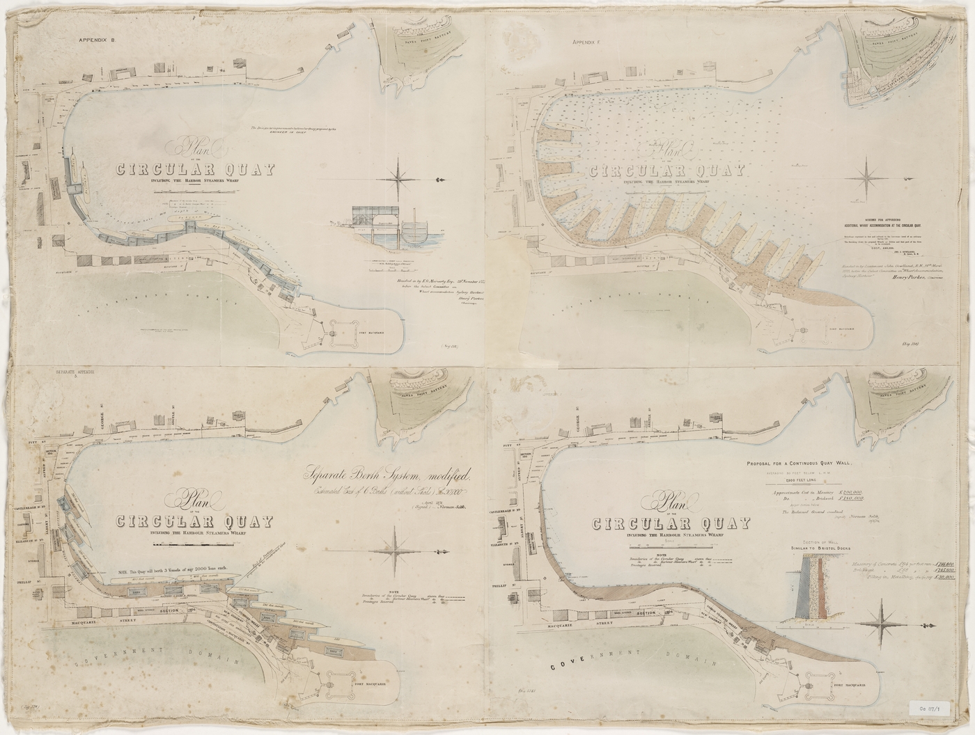
Plan of the Circular Quay including the Harbor Steamers Wharf, scheme for affording additional wharf accommodation at the Circular Quay,
{"type":"image","clickUrl":"https:\/\/prod.corp.slnsw.skpr.live\/collection-items\/plan-circular-quay-including-harbor-steamers-wharf-scheme-affording-additional-1","thumbnail":"https:\/\/prod.corp.slnsw.skpr.live\/sites\/default\/files\/styles\/thumbnail\/https\/s3-ap-southeast-2.amazonaws.com\/prod--slnsw-corporate-site\/uploads\/2018-06\/collection-items\/49906\/a2843001t.jpg?itok=fZ-Rbvmu","thumbnailLarge":"https:\/\/prod.corp.slnsw.skpr.live\/sites\/default\/files\/styles\/large\/https\/s3-ap-southeast-2.amazonaws.com\/prod--slnsw-corporate-site\/uploads\/2018-06\/collection-items\/49906\/a2843001t.jpg?itok=Sz4W-_Dr","mediaDerivativeUrls":{"thumbnail":"https:\/\/prod.corp.slnsw.skpr.live\/sites\/default\/files\/styles\/thumbnail\/https\/s3-ap-southeast-2.amazonaws.com\/prod--slnsw-corporate-site\/uploads\/2018-06\/collection-items\/49906\/a2843001t.jpg?itok=fZ-Rbvmu","large":"https:\/\/prod.corp.slnsw.skpr.live\/sites\/default\/files\/styles\/large\/https\/s3-ap-southeast-2.amazonaws.com\/prod--slnsw-corporate-site\/uploads\/2018-06\/collection-items\/49906\/a2843001t.jpg?itok=Sz4W-_Dr","responsive__quarter_hd":"https:\/\/prod.corp.slnsw.skpr.live\/sites\/default\/files\/styles\/responsive__quarter_hd\/https\/s3-ap-southeast-2.amazonaws.com\/prod--slnsw-corporate-site\/uploads\/2018-06\/collection-items\/49906\/a2843001t.jpg?itok=TBJLpJEP","responsive__half_hd":"https:\/\/prod.corp.slnsw.skpr.live\/sites\/default\/files\/styles\/responsive__half_hd\/https\/s3-ap-southeast-2.amazonaws.com\/prod--slnsw-corporate-site\/uploads\/2018-06\/collection-items\/49906\/a2843001t.jpg?itok=nEd3JJAv","responsive__full_hd":"https:\/\/prod.corp.slnsw.skpr.live\/sites\/default\/files\/styles\/responsive__full_hd\/https\/s3-ap-southeast-2.amazonaws.com\/prod--slnsw-corporate-site\/uploads\/2018-06\/collection-items\/49906\/a2843001t.jpg?itok=2MXrGoXK"},"mediaUrl":"https:\/\/s3-ap-southeast-2.amazonaws.com\/prod--slnsw-corporate-site\/uploads\/2018-06\/collection-items\/49906\/a2843001t.jpg","mediaMime":"image\/jpeg","transcriptUrl":null,"width":160,"height":121}
View collection item detaila2843001
Plan of the Circular Quay including the Harbor Steamers Wharf, scheme for affording additional wharf accommodation at the Circular Quay, by John Gowlland, N. Lieut., R.N. ; (signed) Norman Selfe. John Thomas Ewing Gowlland, Sydney, 1873
a2843005
Circular Quay, Sydney, 1892-1893
{"type":"image","clickUrl":"https:\/\/prod.corp.slnsw.skpr.live\/collection-items\/circular-quay-sydney-0","thumbnail":"https:\/\/prod.corp.slnsw.skpr.live\/sites\/default\/files\/styles\/thumbnail\/https\/s3-ap-southeast-2.amazonaws.com\/prod--slnsw-corporate-site\/uploads\/2018-06\/collection-items\/18781\/a440074r.jpg?itok=hgNR-2xa","thumbnailLarge":"https:\/\/prod.corp.slnsw.skpr.live\/sites\/default\/files\/styles\/large\/https\/s3-ap-southeast-2.amazonaws.com\/prod--slnsw-corporate-site\/uploads\/2018-06\/collection-items\/18781\/a440074r.jpg?itok=1eyrCDGl","mediaDerivativeUrls":{"thumbnail":"https:\/\/prod.corp.slnsw.skpr.live\/sites\/default\/files\/styles\/thumbnail\/https\/s3-ap-southeast-2.amazonaws.com\/prod--slnsw-corporate-site\/uploads\/2018-06\/collection-items\/18781\/a440074r.jpg?itok=hgNR-2xa","large":"https:\/\/prod.corp.slnsw.skpr.live\/sites\/default\/files\/styles\/large\/https\/s3-ap-southeast-2.amazonaws.com\/prod--slnsw-corporate-site\/uploads\/2018-06\/collection-items\/18781\/a440074r.jpg?itok=1eyrCDGl","responsive__quarter_hd":"https:\/\/prod.corp.slnsw.skpr.live\/sites\/default\/files\/styles\/responsive__quarter_hd\/https\/s3-ap-southeast-2.amazonaws.com\/prod--slnsw-corporate-site\/uploads\/2018-06\/collection-items\/18781\/a440074r.jpg?itok=FAeze1qr","responsive__half_hd":"https:\/\/prod.corp.slnsw.skpr.live\/sites\/default\/files\/styles\/responsive__half_hd\/https\/s3-ap-southeast-2.amazonaws.com\/prod--slnsw-corporate-site\/uploads\/2018-06\/collection-items\/18781\/a440074r.jpg?itok=cux9iuri","responsive__full_hd":"https:\/\/prod.corp.slnsw.skpr.live\/sites\/default\/files\/styles\/responsive__full_hd\/https\/s3-ap-southeast-2.amazonaws.com\/prod--slnsw-corporate-site\/uploads\/2018-06\/collection-items\/18781\/a440074r.jpg?itok=jRbOLCTL"},"mediaUrl":"https:\/\/s3-ap-southeast-2.amazonaws.com\/prod--slnsw-corporate-site\/uploads\/2018-06\/collection-items\/18781\/a440074r.jpg","mediaMime":"image\/jpeg","transcriptUrl":null,"width":1200,"height":1003}
View collection item detail a440074
Circular Quay [looking east, showing ferries at wharves, electric trams and a steamship], ca. 1900-1910
{"type":"image","clickUrl":"https:\/\/prod.corp.slnsw.skpr.live\/collection-items\/circular-quay-looking-east-showing-ferries-wharves-electric-trams-and-steamship","thumbnail":"https:\/\/prod.corp.slnsw.skpr.live\/sites\/default\/files\/styles\/thumbnail\/https\/s3-ap-southeast-2.amazonaws.com\/prod--slnsw-corporate-site\/uploads\/2018-06\/collection-items\/49911\/a116168h.jpg?itok=PPoTfk7I","thumbnailLarge":"https:\/\/prod.corp.slnsw.skpr.live\/sites\/default\/files\/styles\/large\/https\/s3-ap-southeast-2.amazonaws.com\/prod--slnsw-corporate-site\/uploads\/2018-06\/collection-items\/49911\/a116168h.jpg?itok=T9qU-uUp","mediaDerivativeUrls":{"thumbnail":"https:\/\/prod.corp.slnsw.skpr.live\/sites\/default\/files\/styles\/thumbnail\/https\/s3-ap-southeast-2.amazonaws.com\/prod--slnsw-corporate-site\/uploads\/2018-06\/collection-items\/49911\/a116168h.jpg?itok=PPoTfk7I","large":"https:\/\/prod.corp.slnsw.skpr.live\/sites\/default\/files\/styles\/large\/https\/s3-ap-southeast-2.amazonaws.com\/prod--slnsw-corporate-site\/uploads\/2018-06\/collection-items\/49911\/a116168h.jpg?itok=T9qU-uUp","responsive__quarter_hd":"https:\/\/prod.corp.slnsw.skpr.live\/sites\/default\/files\/styles\/responsive__quarter_hd\/https\/s3-ap-southeast-2.amazonaws.com\/prod--slnsw-corporate-site\/uploads\/2018-06\/collection-items\/49911\/a116168h.jpg?itok=XpXSelLI","responsive__half_hd":"https:\/\/prod.corp.slnsw.skpr.live\/sites\/default\/files\/styles\/responsive__half_hd\/https\/s3-ap-southeast-2.amazonaws.com\/prod--slnsw-corporate-site\/uploads\/2018-06\/collection-items\/49911\/a116168h.jpg?itok=vUG6R72K","responsive__full_hd":"https:\/\/prod.corp.slnsw.skpr.live\/sites\/default\/files\/styles\/responsive__full_hd\/https\/s3-ap-southeast-2.amazonaws.com\/prod--slnsw-corporate-site\/uploads\/2018-06\/collection-items\/49911\/a116168h.jpg?itok=UEGWjoCQ"},"mediaUrl":"https:\/\/s3-ap-southeast-2.amazonaws.com\/prod--slnsw-corporate-site\/uploads\/2018-06\/collection-items\/49911\/a116168h.jpg","mediaMime":"image\/jpeg","transcriptUrl":null,"width":1400,"height":957}
View collection item detaila116168
Aeroplane view of Sydney, 1914 : Looking southwards Botany Bay as it would be seen from an altitude of about 5,000 feet above North Sydney : With a key to principal places [Album view], 1914
{"type":"image","clickUrl":"https:\/\/prod.corp.slnsw.skpr.live\/collection-items\/aeroplane-view-sydney-1914-looking-southwards-botany-bay-it-would-be-seen-altitude","thumbnail":"https:\/\/prod.corp.slnsw.skpr.live\/sites\/default\/files\/styles\/thumbnail\/https\/s3-ap-southeast-2.amazonaws.com\/prod--slnsw-corporate-site\/uploads\/2018-06\/collection-items\/49916\/a5446001h.jpg?itok=p_Vc08xc","thumbnailLarge":"https:\/\/prod.corp.slnsw.skpr.live\/sites\/default\/files\/styles\/large\/https\/s3-ap-southeast-2.amazonaws.com\/prod--slnsw-corporate-site\/uploads\/2018-06\/collection-items\/49916\/a5446001h.jpg?itok=Pcs1SgFJ","mediaDerivativeUrls":{"thumbnail":"https:\/\/prod.corp.slnsw.skpr.live\/sites\/default\/files\/styles\/thumbnail\/https\/s3-ap-southeast-2.amazonaws.com\/prod--slnsw-corporate-site\/uploads\/2018-06\/collection-items\/49916\/a5446001h.jpg?itok=p_Vc08xc","large":"https:\/\/prod.corp.slnsw.skpr.live\/sites\/default\/files\/styles\/large\/https\/s3-ap-southeast-2.amazonaws.com\/prod--slnsw-corporate-site\/uploads\/2018-06\/collection-items\/49916\/a5446001h.jpg?itok=Pcs1SgFJ","responsive__quarter_hd":"https:\/\/prod.corp.slnsw.skpr.live\/sites\/default\/files\/styles\/responsive__quarter_hd\/https\/s3-ap-southeast-2.amazonaws.com\/prod--slnsw-corporate-site\/uploads\/2018-06\/collection-items\/49916\/a5446001h.jpg?itok=7ZinjqcM","responsive__half_hd":"https:\/\/prod.corp.slnsw.skpr.live\/sites\/default\/files\/styles\/responsive__half_hd\/https\/s3-ap-southeast-2.amazonaws.com\/prod--slnsw-corporate-site\/uploads\/2018-06\/collection-items\/49916\/a5446001h.jpg?itok=6SPReWBD","responsive__full_hd":"https:\/\/prod.corp.slnsw.skpr.live\/sites\/default\/files\/styles\/responsive__full_hd\/https\/s3-ap-southeast-2.amazonaws.com\/prod--slnsw-corporate-site\/uploads\/2018-06\/collection-items\/49916\/a5446001h.jpg?itok=j_rvQwkH"},"mediaUrl":"https:\/\/s3-ap-southeast-2.amazonaws.com\/prod--slnsw-corporate-site\/uploads\/2018-06\/collection-items\/49916\/a5446001h.jpg","mediaMime":"image\/jpeg","transcriptUrl":null,"width":1400,"height":830}
View collection item detaila5446001
Item 24: Walkabout magazine : New South Wales photographs [Sydney housing, hotels, sugar, wheat, ferries & bridges, streets & parks, yachting], 1938-1967
{"type":"image","clickUrl":"https:\/\/prod.corp.slnsw.skpr.live\/collection-items\/item-24-walkabout-magazine-new-south-wales-photographs-sydney-housing-hotels-sugar","thumbnail":"https:\/\/prod.corp.slnsw.skpr.live\/sites\/default\/files\/styles\/thumbnail\/https\/s3-ap-southeast-2.amazonaws.com\/prod--slnsw-corporate-site\/uploads\/2018-06\/collection-items\/49921\/a390002r.jpg?itok=L1MD-gKC","thumbnailLarge":"https:\/\/prod.corp.slnsw.skpr.live\/sites\/default\/files\/styles\/large\/https\/s3-ap-southeast-2.amazonaws.com\/prod--slnsw-corporate-site\/uploads\/2018-06\/collection-items\/49921\/a390002r.jpg?itok=xGXnHvA4","mediaDerivativeUrls":{"thumbnail":"https:\/\/prod.corp.slnsw.skpr.live\/sites\/default\/files\/styles\/thumbnail\/https\/s3-ap-southeast-2.amazonaws.com\/prod--slnsw-corporate-site\/uploads\/2018-06\/collection-items\/49921\/a390002r.jpg?itok=L1MD-gKC","large":"https:\/\/prod.corp.slnsw.skpr.live\/sites\/default\/files\/styles\/large\/https\/s3-ap-southeast-2.amazonaws.com\/prod--slnsw-corporate-site\/uploads\/2018-06\/collection-items\/49921\/a390002r.jpg?itok=xGXnHvA4","responsive__quarter_hd":"https:\/\/prod.corp.slnsw.skpr.live\/sites\/default\/files\/styles\/responsive__quarter_hd\/https\/s3-ap-southeast-2.amazonaws.com\/prod--slnsw-corporate-site\/uploads\/2018-06\/collection-items\/49921\/a390002r.jpg?itok=WILKT1lH","responsive__half_hd":"https:\/\/prod.corp.slnsw.skpr.live\/sites\/default\/files\/styles\/responsive__half_hd\/https\/s3-ap-southeast-2.amazonaws.com\/prod--slnsw-corporate-site\/uploads\/2018-06\/collection-items\/49921\/a390002r.jpg?itok=caSUaWxb","responsive__full_hd":"https:\/\/prod.corp.slnsw.skpr.live\/sites\/default\/files\/styles\/responsive__full_hd\/https\/s3-ap-southeast-2.amazonaws.com\/prod--slnsw-corporate-site\/uploads\/2018-06\/collection-items\/49921\/a390002r.jpg?itok=rFznzhw_"},"mediaUrl":"https:\/\/s3-ap-southeast-2.amazonaws.com\/prod--slnsw-corporate-site\/uploads\/2018-06\/collection-items\/49921\/a390002r.jpg","mediaMime":"image\/jpeg","transcriptUrl":null,"width":800,"height":627}
View collection item detaila390002
Aerial view of Circular Quay and Cahill Expressway, c.1963, , 1954-1967
{"type":"image","clickUrl":"https:\/\/prod.corp.slnsw.skpr.live\/collection-items\/aerial-view-circular-quay-and-cahill-expressway-c1963","thumbnail":"https:\/\/prod.corp.slnsw.skpr.live\/sites\/default\/files\/styles\/thumbnail\/https\/s3-ap-southeast-2.amazonaws.com\/prod--slnsw-corporate-site\/uploads\/2018-06\/collection-items\/49926\/a383002r.jpg?itok=omnO2HuC","thumbnailLarge":"https:\/\/prod.corp.slnsw.skpr.live\/sites\/default\/files\/styles\/large\/https\/s3-ap-southeast-2.amazonaws.com\/prod--slnsw-corporate-site\/uploads\/2018-06\/collection-items\/49926\/a383002r.jpg?itok=vxDL4m5d","mediaDerivativeUrls":{"thumbnail":"https:\/\/prod.corp.slnsw.skpr.live\/sites\/default\/files\/styles\/thumbnail\/https\/s3-ap-southeast-2.amazonaws.com\/prod--slnsw-corporate-site\/uploads\/2018-06\/collection-items\/49926\/a383002r.jpg?itok=omnO2HuC","large":"https:\/\/prod.corp.slnsw.skpr.live\/sites\/default\/files\/styles\/large\/https\/s3-ap-southeast-2.amazonaws.com\/prod--slnsw-corporate-site\/uploads\/2018-06\/collection-items\/49926\/a383002r.jpg?itok=vxDL4m5d","responsive__quarter_hd":"https:\/\/prod.corp.slnsw.skpr.live\/sites\/default\/files\/styles\/responsive__quarter_hd\/https\/s3-ap-southeast-2.amazonaws.com\/prod--slnsw-corporate-site\/uploads\/2018-06\/collection-items\/49926\/a383002r.jpg?itok=TiYoZk06","responsive__half_hd":"https:\/\/prod.corp.slnsw.skpr.live\/sites\/default\/files\/styles\/responsive__half_hd\/https\/s3-ap-southeast-2.amazonaws.com\/prod--slnsw-corporate-site\/uploads\/2018-06\/collection-items\/49926\/a383002r.jpg?itok=K1HdUeTP","responsive__full_hd":"https:\/\/prod.corp.slnsw.skpr.live\/sites\/default\/files\/styles\/responsive__full_hd\/https\/s3-ap-southeast-2.amazonaws.com\/prod--slnsw-corporate-site\/uploads\/2018-06\/collection-items\/49926\/a383002r.jpg?itok=QzPxUgn4"},"mediaUrl":"https:\/\/s3-ap-southeast-2.amazonaws.com\/prod--slnsw-corporate-site\/uploads\/2018-06\/collection-items\/49926\/a383002r.jpg","mediaMime":"image\/jpeg","transcriptUrl":null,"width":800,"height":645}
View collection item detail a383002
East Circular Quay Sydney Cove, 1995, 1995-2009
{"type":"image","clickUrl":"https:\/\/prod.corp.slnsw.skpr.live\/collection-items\/east-circular-quay-sydney-cove-1995","thumbnail":"https:\/\/prod.corp.slnsw.skpr.live\/sites\/default\/files\/styles\/thumbnail\/https\/s3-ap-southeast-2.amazonaws.com\/prod--slnsw-corporate-site\/uploads\/2018-06\/collection-items\/49931\/a3218001r.jpg?itok=MGZCXOWw","thumbnailLarge":"https:\/\/prod.corp.slnsw.skpr.live\/sites\/default\/files\/styles\/large\/https\/s3-ap-southeast-2.amazonaws.com\/prod--slnsw-corporate-site\/uploads\/2018-06\/collection-items\/49931\/a3218001r.jpg?itok=B28xqQsW","mediaDerivativeUrls":{"thumbnail":"https:\/\/prod.corp.slnsw.skpr.live\/sites\/default\/files\/styles\/thumbnail\/https\/s3-ap-southeast-2.amazonaws.com\/prod--slnsw-corporate-site\/uploads\/2018-06\/collection-items\/49931\/a3218001r.jpg?itok=MGZCXOWw","large":"https:\/\/prod.corp.slnsw.skpr.live\/sites\/default\/files\/styles\/large\/https\/s3-ap-southeast-2.amazonaws.com\/prod--slnsw-corporate-site\/uploads\/2018-06\/collection-items\/49931\/a3218001r.jpg?itok=B28xqQsW","responsive__quarter_hd":"https:\/\/prod.corp.slnsw.skpr.live\/sites\/default\/files\/styles\/responsive__quarter_hd\/https\/s3-ap-southeast-2.amazonaws.com\/prod--slnsw-corporate-site\/uploads\/2018-06\/collection-items\/49931\/a3218001r.jpg?itok=F1VXQSZP","responsive__half_hd":"https:\/\/prod.corp.slnsw.skpr.live\/sites\/default\/files\/styles\/responsive__half_hd\/https\/s3-ap-southeast-2.amazonaws.com\/prod--slnsw-corporate-site\/uploads\/2018-06\/collection-items\/49931\/a3218001r.jpg?itok=FQuniOGP","responsive__full_hd":"https:\/\/prod.corp.slnsw.skpr.live\/sites\/default\/files\/styles\/responsive__full_hd\/https\/s3-ap-southeast-2.amazonaws.com\/prod--slnsw-corporate-site\/uploads\/2018-06\/collection-items\/49931\/a3218001r.jpg?itok=JpA7368A"},"mediaUrl":"https:\/\/s3-ap-southeast-2.amazonaws.com\/prod--slnsw-corporate-site\/uploads\/2018-06\/collection-items\/49931\/a3218001r.jpg","mediaMime":"image\/jpeg","transcriptUrl":null,"width":800,"height":535}
View collection item detaila3218002
East Circular Quay, Sydney Cove, 2009, 2009
{"type":"image","clickUrl":"https:\/\/prod.corp.slnsw.skpr.live\/collection-items\/east-circular-quay-sydney-cove-2009","thumbnail":"https:\/\/prod.corp.slnsw.skpr.live\/sites\/default\/files\/styles\/thumbnail\/https\/s3-ap-southeast-2.amazonaws.com\/prod--slnsw-corporate-site\/uploads\/2018-06\/collection-items\/49936\/a3218002r.jpg?itok=F2O4d5kC","thumbnailLarge":"https:\/\/prod.corp.slnsw.skpr.live\/sites\/default\/files\/styles\/large\/https\/s3-ap-southeast-2.amazonaws.com\/prod--slnsw-corporate-site\/uploads\/2018-06\/collection-items\/49936\/a3218002r.jpg?itok=Egrv4_VO","mediaDerivativeUrls":{"thumbnail":"https:\/\/prod.corp.slnsw.skpr.live\/sites\/default\/files\/styles\/thumbnail\/https\/s3-ap-southeast-2.amazonaws.com\/prod--slnsw-corporate-site\/uploads\/2018-06\/collection-items\/49936\/a3218002r.jpg?itok=F2O4d5kC","large":"https:\/\/prod.corp.slnsw.skpr.live\/sites\/default\/files\/styles\/large\/https\/s3-ap-southeast-2.amazonaws.com\/prod--slnsw-corporate-site\/uploads\/2018-06\/collection-items\/49936\/a3218002r.jpg?itok=Egrv4_VO","responsive__quarter_hd":"https:\/\/prod.corp.slnsw.skpr.live\/sites\/default\/files\/styles\/responsive__quarter_hd\/https\/s3-ap-southeast-2.amazonaws.com\/prod--slnsw-corporate-site\/uploads\/2018-06\/collection-items\/49936\/a3218002r.jpg?itok=xXcvPKgH","responsive__half_hd":"https:\/\/prod.corp.slnsw.skpr.live\/sites\/default\/files\/styles\/responsive__half_hd\/https\/s3-ap-southeast-2.amazonaws.com\/prod--slnsw-corporate-site\/uploads\/2018-06\/collection-items\/49936\/a3218002r.jpg?itok=6DVC2ZJk","responsive__full_hd":"https:\/\/prod.corp.slnsw.skpr.live\/sites\/default\/files\/styles\/responsive__full_hd\/https\/s3-ap-southeast-2.amazonaws.com\/prod--slnsw-corporate-site\/uploads\/2018-06\/collection-items\/49936\/a3218002r.jpg?itok=6U2bpR4H"},"mediaUrl":"https:\/\/s3-ap-southeast-2.amazonaws.com\/prod--slnsw-corporate-site\/uploads\/2018-06\/collection-items\/49936\/a3218002r.jpg","mediaMime":"image\/jpeg","transcriptUrl":null,"width":800,"height":531}
View collection item detaila3218002


